BiDaE
provides real-time indoor location data and flexible tools customized to meet
decision support needs of your enterprise.
We will customize the indoor positioning platform, location data, and location-based tools and apps provided to you to meet your monitoring and management needs and support your practices in care delivery and asset management. We will continuously evolve our solutions as technology advances and your needs change.
BiDaE indoor Positioning System (BPS) supports not only BiDaE’s own object tracker and mobile navigation app. Through its open API, the platform also can provide real-time indoor location data and positioning services to third party applications and services.
BiDaE object tracker can locate tagged devices/equipment for you in a second or two. The system also let you request repair, reserve use and record loans of individual devices and equipment.
You can also locate people and keep an eye on them: The object tracker lets you read remotely vital signs of people wearing smart watches, watch over lone workers, and monitor the movements of visitors/contractors.
Visitors to your place will appreciate Seeing-I-Go, BiDaE‘s indoor mobile wayfinding and navigation app. It works well for people on foot and in wheelchairs even amidst crowd, especially for vision impaired users.
Tools exploiting location data can save time needed to do tasks such as generation of shift change records and adherence check of rounding schedules. Many such tools are available or can be added easily.
You can request from object tracker reports on object locations, schedule adherence and proximity relations based on stored data. Reports for other use cases can be created from available customizable templates.
Many capabilities of object tracker are made possible by time-stamped location traces of monitored objects collected by the system over time. Contact tracing is an example. Other examples include management of contractors and deliverers.
Geofences can be set up to let you control access and prevent theft to and from buildings, floors, and large areas on floors. Location monitors are suited for monitoring rooms.
Available alarms include emergency and safety alarms. A tag wearer can call for help by pushing the button on the tag. You can set up for an object a safety notification to alert persons in proximity of the object.
Our Customers and Collaborators
BLE Beacon IoT Project
(Part of Accessible Traveler Mobile App Pilot Project)
Collaborators:
Access Services, Los Angeles, CA, USA IT Curves, Gaithersburg, MD, USA
Test site:
Rancho Los Amigos National Rehabilitation Center, Los Angeles, CA, with 19 destinations in outpatient area and 2 shuttle stops outdoors
Products evaluated:
BPS, Seeing-I-Go and the precision docking extension of Seeing-I-Go designed to help each vision-impaired user identify user’s pickup shuttle and locate the shuttle door.
Lessons learned:
Usability of BPS and Seeing-I-Go are are good when used to guide riders between shuttle stops and indoor destinations.
Usability of Seeing-I-Go in accessibiltiy mode is good: It can serve vision impaired riders well.
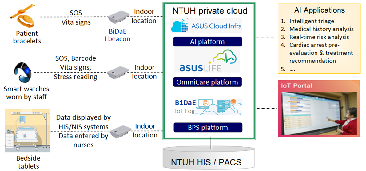
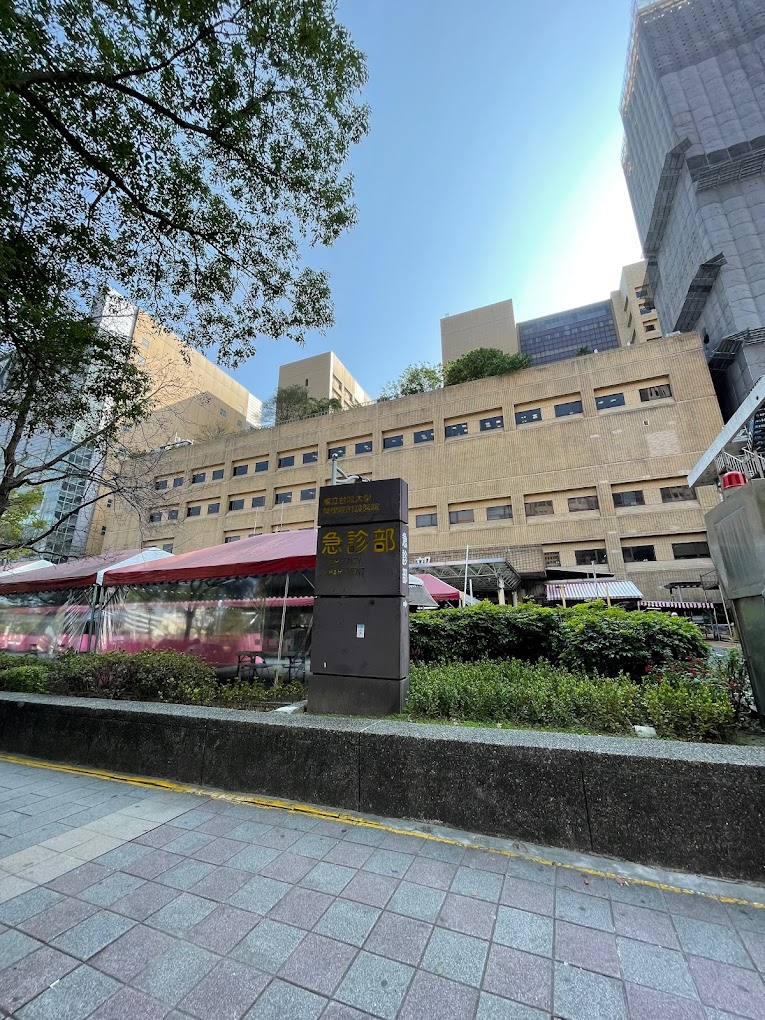
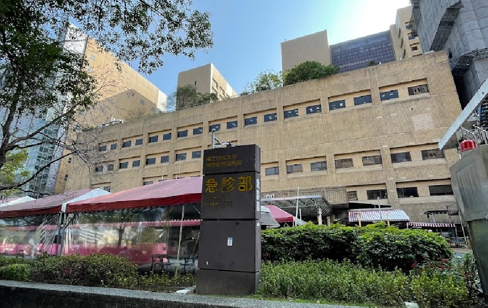
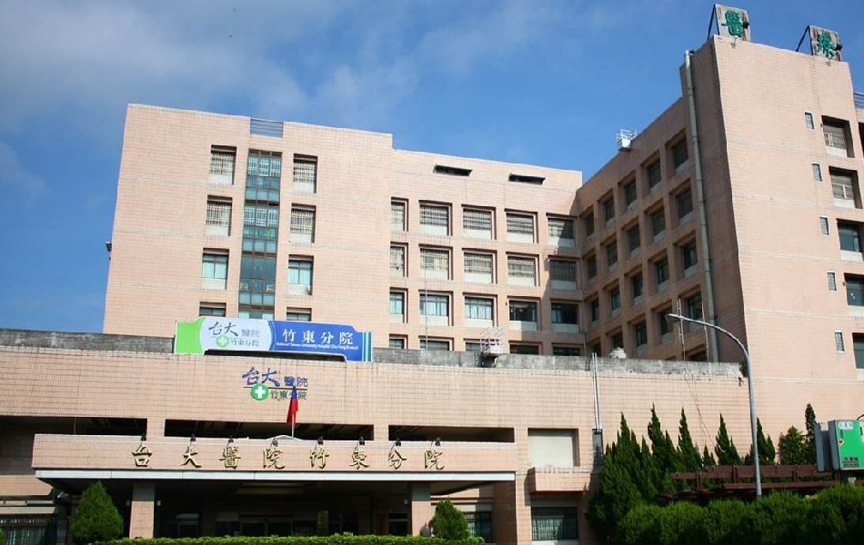
A 2020-2022 joint project of Taiwan Ministry of Science and Technology Joint Research Center for AI Technology, National Taiwan University Hospital Emergency Department and ASUS Life
BiDaE Positioning System (BPS) is deployed to provide real-time indoor location services. It covers 2,500 square meters of the Emergency Department and areas where mobile beds can be and uses 180 Lbeacons to achieve 3-5 meter or 5-10 m location accuracy. It is designed to respond within 2 seconds to tens of concurrent searches of hundreds of devices, equipment and people.
BPS is deployed to support navigation in outpatient area of Douliu Campus. Within 2024, object tracking with location accuracy as needed by applications will be supported throughout both campuses;
Seeing-I-Go is available in Douliu compus to guide outpatients to the doctors’ offices and labs on their appointment lists.
Object tracker enables staff in patent wards to locate devices with room-level accuracy. It also provides them with all operation support functions, including generation of shift change records and object traces.
Object tracker is also used to track movements of devices and delivery persons.
In 2020, Yunlin branch won the National Healthcare Quality Award and the National Innovation Award.
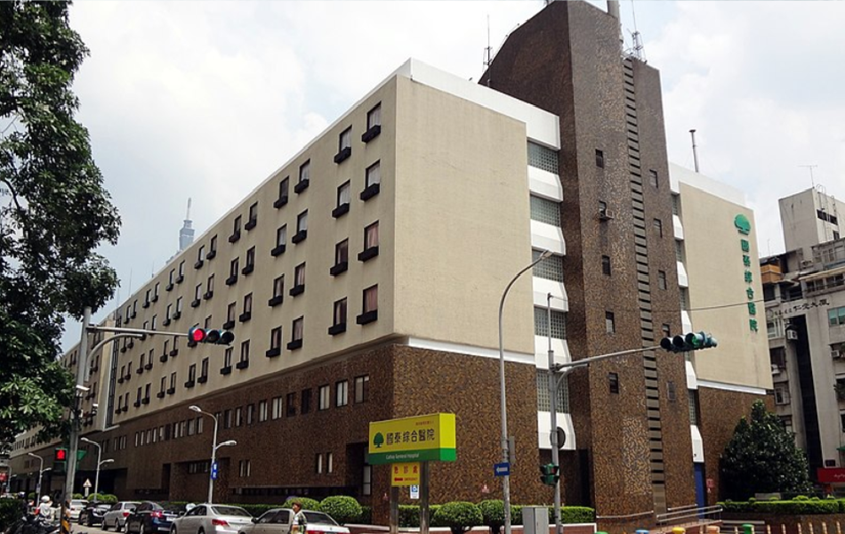
Object tracker can locate in real-time hundreds of objects with 3-5 or 5-10 meter accuracy within the entire Emergency Department and hallways where mobile beds can be.
BiDaE indoor positioning system supports via its API 3rd party patient/caretaker monitoring and bed management apps.
BiDaE object tracker is deployed in the Main and the First Buildings to provide search and locate capability needed for fully intelligent mobile medical devices and bed management. It is configured to achieve zone and floor level location accuracy.
In 2023, Cathay Hospital for its use of intelligent mobile bed management won both the Creative Award and the Badge Award of the National Healthcare Quality Award.
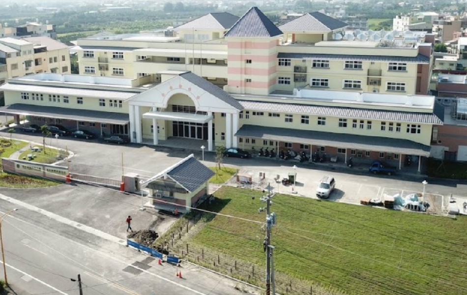
Object tracker provides geofences and location monitors to enforce confinement of visitors to visiting areas and residents with infections to isolation areas.
The system enables the staff to monitor vital signs of residents remotely and generate hourly rounding schedule adherence reports, etc.
The home won National Medical Care Quality Award in 2021.
Formosa Chemical and Fiber Corp.
Hsinkang PABS Plant
UMC Headquarters
8AB, UT, 8CD SUB, CUB Plants
Formosa Chemical and Fiber Corp.
Hsinkang PABS Plant
Object tracker is used to ensure worker safety. Lone workers wear sensor tags with accelerometers on their hard hats, enabling the system to monitor minute motions. When the system detects the absence of motion of any wearer, it calls specified person(s) to take appropriate actions.
The object tracker is also used to monitor contractors. It ensures that they are at their workplaces at all times, except during rest and meal breaks.
BiDaE Object Tracker is used by UMC in its headquarter building and 8AB, 8CD SUB and CUB plants to monitor and track deliverers. Each type of deliverers has a delivery route and a time limit for staying in the buildings. The system is to issue an alarm whenever any deliverer is found to deviate from the route or overstay the time limit of the deliverer type.
The system can be expanded to monitor other types of people, e.g., visitors, contractors, and employees. It can also be modified easily to cover buildings at other company sites.
(Part of Accessible Traveler Mobile App Pilot Project)
Collaborators:
Access Services, Los Angeles, CA, USA IT Curves, Gaithersburg, MD, USA
Test site:
Rancho Los Amigos National Rehabilitation Center, Los Angeles, CA, with 19 destinations in outpatient area and 2 shuttle stops outdoors
Products evaluated:
BPS, Seeing-I-Go and the precision docking extension of Seeing-I-Go designed to help each vision-impaired user identify user’s pickup shuttle and locate the shuttle door.
Lessons learned:
Usability of BPS and Seeing-I-Go are are good when used to guide riders between shuttle stops and indoor destinations.
Usability of Seeing-I-Go in accessibiltiy mode is good: It can serve vision impaired riders well.
A 2020-2022 joint project of Taiwan Ministry of Science and Technology Joint Research Center for AI Technology, National Taiwan University Hospital Emergency Department and ASUS Life
BiDaE Positioning System (BPS) is deployed to provide real-time indoor location services. It covers 2,500 square meters of the Emergency Department and areas where mobile beds can be and uses 180 Lbeacons to achieve 3-5 meter or 5-10 m location accuracy. It is designed to respond within 2 seconds to tens of concurrent searches of hundreds of devices, equipment and people.
BPS is deployed to support navigation in outpatient area of Douliu Campus. Within 2024, object tracking with location accuracy as needed by applications will be supported throughout both campuses;
Seeing-I-Go is available in Douliu compus to guide outpatients to the doctors’ offices and labs on their appointment lists.
Object tracker enables staff in patent wards to locate devices with room-level accuracy. It also provides them with all operation support functions, including generation of shift change records and object traces.
Object tracker is also used to track movements of devices and delivery persons.
In 2020, Yunlin branch won the National Healthcare Quality Award and the National Innovation Award.
Object tracker can locate in real-time hundreds of objects with 3-5 or 5-10 meter accuracy within the entire Emergency Department and hallways where mobile beds can be.
BiDaE indoor positioning system supports via its API 3rd party patient/caretaker monitoring and bed management apps.
BiDaE object tracker is deployed in the Main and the First Buildings to provide search and locate capability needed for fully intelligent mobile medical devices and bed management. It is configured to achieve zone and floor level location accuracy.
In 2023, Cathay Hospital for its use of intelligent mobile bed management won both the Creative Award and the Badge Award of the National Healthcare Quality Award.
Object tracker provides geofences and location monitors to enforce confinement of visitors to visiting areas and residents with infections to isolation areas.
The system enables the staff to monitor vital signs of residents remotely and generate hourly rounding schedule adherence reports, etc.
The home won National Medical Care Quality Award in 2021.
Formosa Chemical and Fiber Corp.
Hsinkang PABS Plant
UMC Headquarters
8AB, UT, 8CD SUB, CUB Plants
Formosa Chemical and Fiber Corp.
Hsinkang PABS Plant
Object tracker is used to ensure worker safety. Lone workers wear sensor tags with accelerometers on their hard hats, enabling the system to monitor minute motions. When the system detects the absence of motion of any wearer, it calls specified person(s) to take appropriate actions.
The object tracker is also used to monitor contractors. It ensures that they are at their workplaces at all times, except during rest and meal breaks.
BiDaE Object Tracker is used by UMC in its headquarter building and 8AB, 8CD SUB and CUB plants to monitor and track deliverers. Each type of deliverers has a delivery route and a time limit for staying in the buildings. The system is to issue an alarm whenever any deliverer is found to deviate from the route or overstay the time limit of the deliverer type.
The system can be expanded to monitor other types of people, e.g., visitors, contractors, and employees. It can also be modified easily to cover buildings at other company sites.
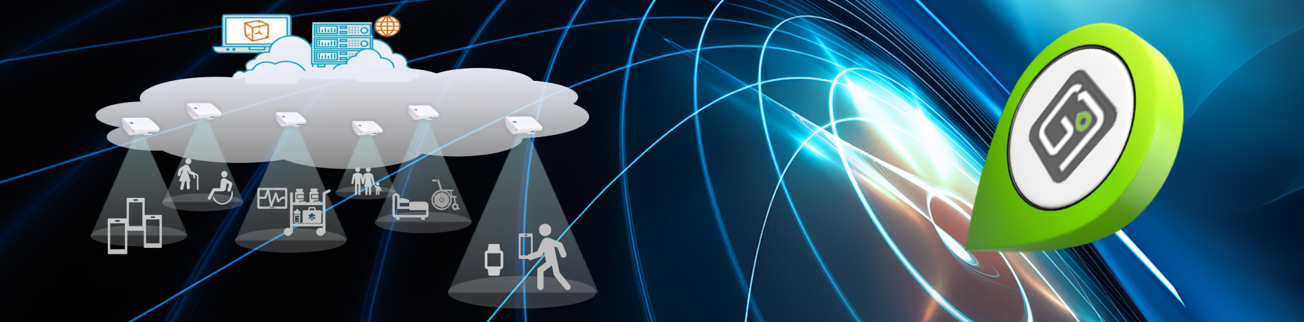
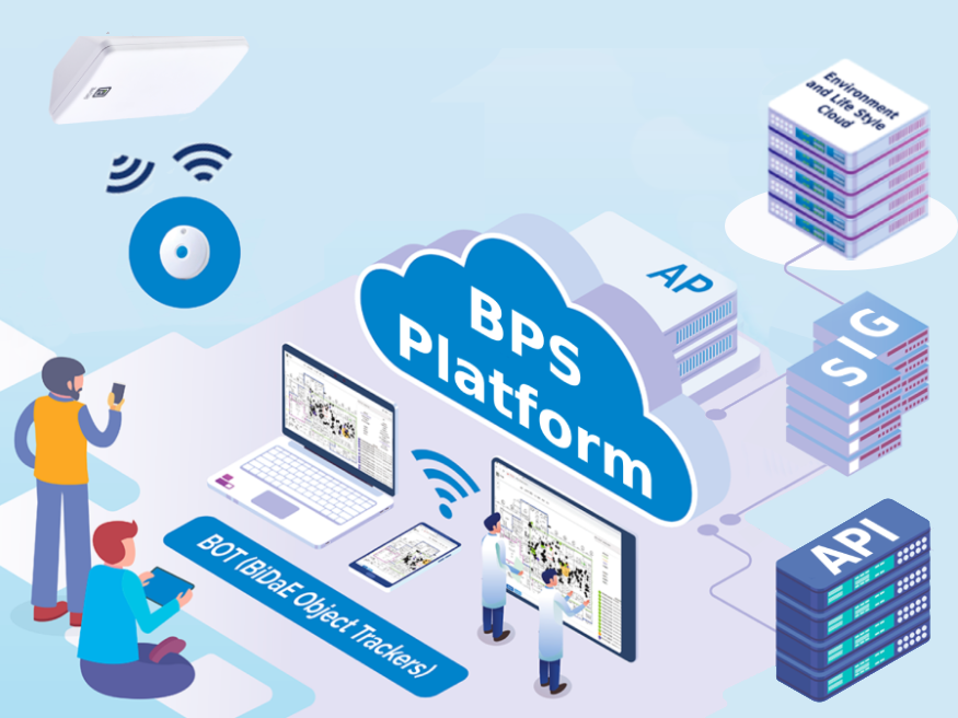
BiDaE indoor Positioning System, or BPS for short, is an open platform for indoor navigation and real-time indoor object tracking applications: It supports BiDaE’s own Seeing-I-Go mobile app and BiDaE Object Tracker. Through its open API, the platform also can provide indoor position and object location data to diverse third party apps and services.
The work done by BPS is carried out collaboratively by two types of components: tags and location beacons (Lbeacons). Together, they form a fog of Internet of Things (IoT).
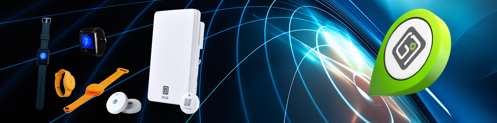
Simple and sensor tags
Tags are Bluetooth Low Energy (BLE) transmitters. Every tag has a universally unique identifier (UUID). It broadcasts continuously advertizing packets containing its UUID and thus makes its presence known to Bluetooth receivers near by. Object tracking systems use of this feature to make objects to be located and tracked visible to the system: This is done by attaching to (or wearing by) every object to be visible to the system a tag and storing in the server an association of the tag UUID with the object ID/name. Thus, the location of each visible object is given by the location of the associated tag.
There are two types of tags: simple tags and sensor tags. Simple tags do nothing but broadcasting their UUID’s. Sensor tag contains sensors. In addition to its UUID, each sensor tag also broadcasts readings of its sensor(s) periodically. Smart watches are examples. Each watch reads and broadcasts regularly vital signs of the person wearing it. Some sensor tags can provide acceleration readings. A real-time object tracker can use them to support remote vital sign and movement monitors.
Location beacons (Lbeacons)
Lbeacons are a BLE transceivers. They are powered by AC or PoE (power over Ethernet) and are connected to the BPS server via WiFi or Ethernet. In a building served by a BPS, they are installed throughout the area covered by the system.
Each Lbeacon broadcasts continuously its own 3D coordinates or UUID via a directional antenna to devices in its coverage area of a few meters in radius. Thus, it provides navigation apps on the devices with position data. Each Lbeacon also scans its coverage area continuously. When it hears a tag, it sends to the server the tag’s UUID, its own UUID, and the time interval during which the tag is heard. Based on data from all Lbeacons, the server determines the location of every tag at all times. Every Lbeacon also forwards to the server time stamped sensor readings from every sensor tag. Thus, BPS effectively functions as a sensor data crowdsourcing system.
Location accuracy
The vertical location of every tag reported by BPS is in terms of the floor level on which the tag is. This data is always accurate. The system can be configured to achieve a wide range of horizontal location accuracy by making use of more or fewer Lbeacons. In order to bring the user to within sight of sought-after objects, Lbeacons need to be configured to achieve than 3-5 meters or 5-10 meters horizontal accuracy. This is often referred to as bed/desk-level or room-level accuracy, respectively. In hospitals and other healthcare facilities, this configuration is typically used for areas such as emergency department and patient wards. Often, zone-level (i.e., 10-20+ meter) or floor-level accuracy in all or some areas suffices. This setting is usually used when the goal is to determine whether the sought-after object is in the building, or on which floor, in which patient ward or which part of a ward.
Dual functionality – Can serve as platform for both indoor positioning and navigation and indoor object tracking apps/services.
Sufficient location accuracy – Can provide 3-5 m (bed-level), 5-10 m (room-level), and 10- 20+ m (zone-level) location accuracy.
Sufficiently good response time – Can response to searches within 2 seconds and present locations of moving objects in 10 seconds.
Scalability and robustness – Location accuracy and interactive response time are negligibly affected by presence of thousands of objects and hundreds of concurrent searches.
Configurability and enhancement – Can be easily configured, deployed and enhanced to support different functions and achieve different accuracies.
Openness – Open API’s enable applications and services developed by others to use BPS to locate and track their objects and provide indoor positioning support for their navigation apps. (See BPS API Specification)
Maintainability – Health conditions of Lbeacons and battery status of tags can be monitored centrally and Lbeacon health restored remotely.
BiDaE Object Tracker
BiDaE Object Tracker (or BOT for short) is a system of software tools for use within hospitals, elderly care facilities, office buildings, factories, etc. Its primary function is to help you locate objects, i.e., devices, equipment, people, etc. BOT also has tools to support your decisions and streamline your work processes and tools to help your organization prevent theft, follow best practices in device/equipment management, control building access, ensure safety of people, and so on.
System structure
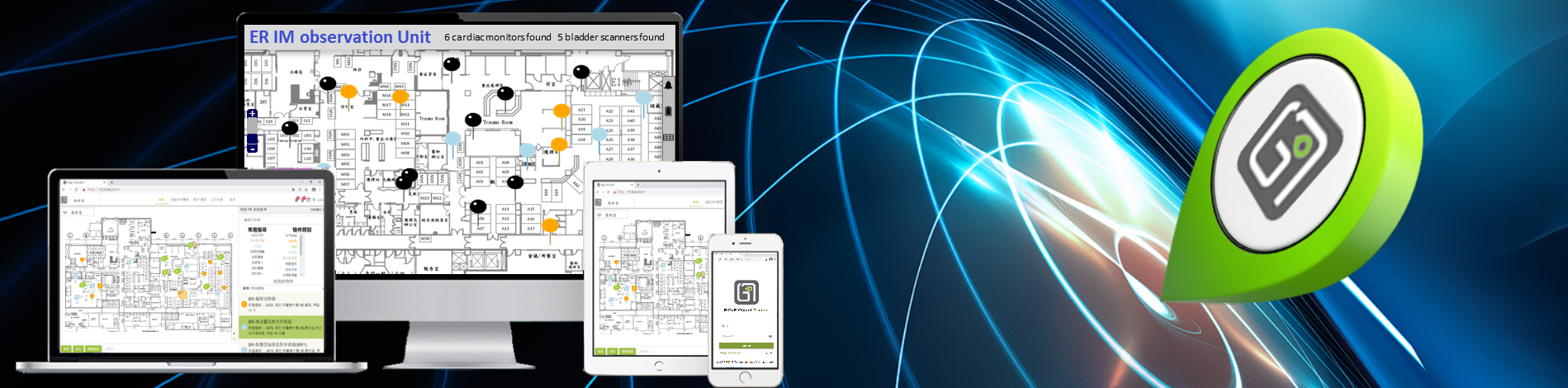
You can think of BOT as an intelligent database on the platform BiDaE indoor Positioning System (BPS) deployed in the space covered by the BOT. You access the data and tools provided by it via its browser-based graphical user interface (GUI). The data stored in the database are collected collaboratively by Bluetooth tags and Lbeacons (Location beacon). They are components of BPS.
Tags are battery powered transmitters. Each tag has a UUID (Universally Unique ID) and continuously broadcasts the UUID. When in use by BOT, it is attached to, or worn by, an object to be located and tracked. The system maintains an association of the tag UUID and the name/ID of the object. By doing so, the location of the object is given the location of the associated tag.
Lbeacons are transceivers powered by AC or Power over Ethernet and are connected via WiFi or Ethernet to the BPS server. Each Lbeacon is located at a location known to the server and has a coverage area a few meters in radius. It continuously scans the area. When it hears a tag, it sends to the server the tag’s UUID, its own UUID and the time interval during which the tag is heard. Based on data from all Lbeacons, the server determines the locations of all tags/objects at all time and store the data in the database.
Clearly, BOT inherits the advantages of BPS: Depending on users’ needs, it can be configured to provide 3-5 m, 5-10 m, and 10- 20+ m location accuracy. It can response in timely fashion to hundreds of concurrent searches for thousands of objects. It is robust, scalable and easy to deploy, customize and maintain. Finally, it is available for 99.95 % of the time.
Distinct features
In addition to advantages inherited from the underlying BPS platform, BOT has the following distinct features:
User-centered design: BOT is designed from a user-centered perspective to maximize usability. Its browser-based user interface and supports for single-sign-on and multi-device usage enable you to access BOT anywhere.
Role-based access control: The data BOT presents to you, areas it lets you see and actions it allows you to take depend on your role within your organization. They are what deemed necessary for you to do your work effectively.
Customization and personalization: BOT configuration and setting tools enable your department and organization to customize easily almost everything, from names of objects, object types, locations and user-defined object types, to role-based access control model, to how the display looks, when and how alerts and notifications are delivered and so on.
Core capabilities
Core capabilities provided by every BOT include the following:
Location and object searches: You can search for the location(s) of an object or all objects of a type. In response, BOT will return a summary of search results, lists of objects found and objects not found, and location pins representing the objects found on the map of the area covered by the search. You can also search for all objects at a location or a list of locations of interest. The result of such a search contains IDs/names of all objects found at the location(s).
Operation support functions: BOT makes it convenient for you to generate repair requests for devices/equipment whenever you find them needing attention and records of loans and return of devices to and from other departments and organizations. You can also write and record notes anywhere on monitored people and monitor remotely vital signs and movements of people wearing smart watches and tags with acceleration sensors.
Emergency alarm: Whenever the panic button on any tag is pushed, the system sends an alarm to specified recipient(s). Available alarm delivery methods include warning lights, warning music, alarm bells, SMS and email notification, and video from nearby CCTV.
Historical records: BOT automatically records occurrences of events (e.g. alarms) and user actions (e.g., request device repair) that change status of some objects. Upon request, records are made available to users with the privilege to see them.
Setting and customization tools and administration functions: In addition to tools for specifying preferences and customizing the core functions, every BOT also provides tools for managing itself and the underlying BPS. Examples of such functions include add/delete user accounts, add/delete objects, show tag battery status, and so on.
Advanced and custom capabilities
The system provides many advanced and custom functions. They are included in your BOT upon request by your organization.
Shift change support: During shift changes, it may take 10’s of minutes or longer to find all the devices/equipment under your care and record their locations. By leveraging BOT’s search capability, the shift change record generator can reduce the required time to a minute or two. Also available are flexible tools for making device and patient assignments.
Safety Notification: You can request the location of a specified patient be monitored and a notification stating the reason for the alert be delivered to designated recipient(s) upon the patient’s arrival to any of the specified areas for sake of enhanced safety. (For example, you can alert the reception desk of the CT-Scan lab this way when you send a patient with infectious skin condition or rare allergy to rubbing alcohol there to be examined.) The function can be generalized as needed to monitor other types of objects.
Geo-fences: A geo-fence is a boundary of a geographic area. Each crossing of the boundary by a monitored object triggers an alert. BOT provides two types of geo-fences. A peripheral fence enclosing a contiguous area can be used to detect unauthorized movements of specified objects entering or leaving the area. A floor separator marks the boundaries between floors in a multi-story building and is used to detect the presence of monitored objects on floors where they are prohibited. In addition to its on-time and off-time, each geo-fence can be configured to deliver notifications in specified forms (e.g., via audio alarm and/or flashing lights, streaming videos from nearby CCTV on the screen, and/or short message to designated receivers).
Location and movement monitors: These monitors are used to keep a close watch on monitored objects. Each monitor is defined by a monitored condition. It is to trigger and deliver an alert when the monitored condition is violated. Location monitors are used to enforce location restrictions of monitored objects at specified locations. Each location monitor is specified by confined-to or disallowed locations during specified time intervals. Examples include “No patient in hallways from 20:00 to 5:00” and “Every contractor is at the contractor’s workplace.” Movement monitors are concerned with movements or lack of movements of the monitored persons. An example of monitored conditions is “Joe Doe has moved in the past minute.” used to define a monitor for safeguarding lone factory workers.
Report generation: Standard reports provided by BOT are parameter driven. Each report has fix but customizable contents and format. These features enable you and your colleagues to produce reports for diverse purposes, ranging from routine bookkeeping to business intelligence analyses.
Currently BOT provides three types of standard reports: They are object location reports, schedule adherence reports and object movement and proximity reports. Many reports of importance are of object location type. Such a report typically provides average fractions or lengths of time each object of interest spends each day within the specified time window at locations of interest. As an example, a resident activity report of a nursing home provides estimates of the average fractions of time per day residents of interest spend in their own rooms, recreation hall, exercise room, etc. Another example is a device utilization report. It provides the average fraction of time during each day when devices of interest are not in storage room and hence are in use.
Schedule adherence/conformance reports typically provide for each location of interest, time between visits and length of stay per visit by each or any of the specified objects of interest. Many tasks are supposed to be done according to planned schedules: Examples include hourly rounding by care providers, security personals touring their assigned checkpoints, deliveries by contract delivery persons, and so on. Statistics in schedule adherence reports can provide an overview/summary on how close such tasks are carried out by specified individuals according to their respective assigned schedules as well as information needed to identify where performance falls short and how it can be improved.
Object movement reports aim to present movements of objects of interest in ways easy for you to visualize. Object trace records are examples. The available object trace tool enables you generate trace(s) of selected objects starting from time when you make the request for a specified duration in the future. Similar traces based on stored location data can be generated by report generator. In addition, you can request object proximity reports. A proximity report provides information on objects and/or locations that have been within proximity of one another for a specified length of time or longer. Contact tracing graphs used to control infectious decease epidemics are forms of proximity reports.
Seeing-I-Go, the mobile navigation app from BiDaE
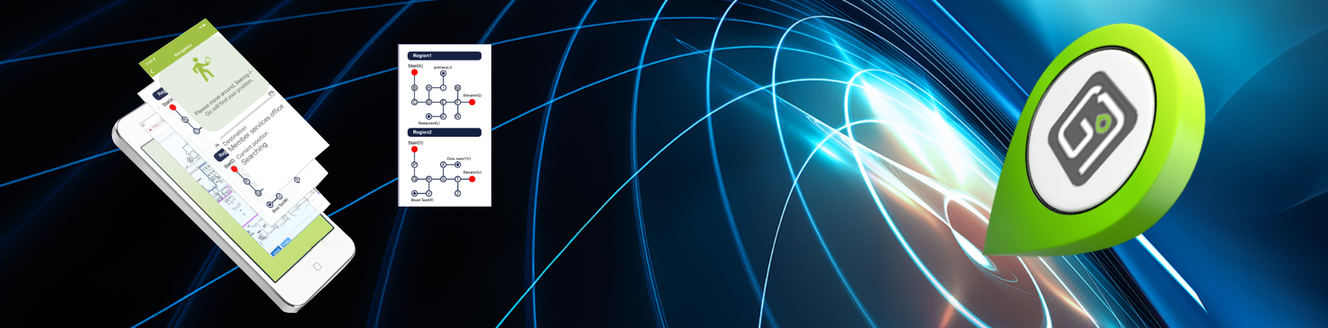
Seeing-I-Go is the mobile Bluetooth navigation app offered by BiDaE. You can use it to guide you in building complexes indoors and outdoor spaces around buildings. Its user interface is simple and easy to use and does not require you to look at the screen for long and frequently. Its distinct features include
It presents turn-by-turn navigation directions in simple spoken language, text and visual displays;
It uses routes for you according to your preferences and settings;
It works with simple navigation maps containing names and locations of destinations and pathways traversable by persons on foot and wheelchairs connecting the destinations;
It can warn you of obstacles ahead along your path; and
It can use accessibility features of modern smartphones to serve vision impaired users.
Today, different buildings in a building complex or parts of a large building may deploy indoor positioning systems based on different technologies. Seeing-I-Go can work anywhere, switching transparently to the user between different underlying indoor positioning systems. In addition to navigation, Seeing-I-Go can be extended to collaborate with other mobile apps. For example, in Los Angeles USA, it has been integrated with a rider information app to guide vision-impaired bus riders between their bus stops to indoor destinations and during the return trip idientify their pickup vehicles and locate the vehicle’s boarding door/ramp. Seeing-I-Go can also be extended to provide scheduling service for diverse purposes. An example of resultant apps is outpatient assistant: When provided with the patient’s appointments and doctors’ orders for the day, the app minimizes the total time the patient needs to spend to completey all the appointments on the list in addition to guiding the patient to go from appointment to appointment.
You can find how Seeing-I-Go works and how to download and install the app on iPhones and Android phones, as well as where to find available navigation maps, from the white paper Seeing-I-Go at a Glance.